• Space/Science
  • GeekSpeak
  • Mysteries of
    the Multiverse
  • Science Fiction
  • The Comestible Zone
  • Off-Topic
  • Community
  • Flame
  • CurrentEvents

Recent posts

Starship V3 set to make its first launch 6:30pm ET on Monday, May 19 BuckGalaxy May 12, 2026 4:52 pm (Space/Science)

Good idea, for what it's worth... BuckGalaxy May 11, 2026 11:00 pm (CurrentEvents)

Consequences of the Orange Moron's idiotic war BuckGalaxy May 11, 2026 1:36 am (CurrentEvents)

How are you supposed to win a war when you avoid killing people RobVG May 8, 2026 5:47 pm (CurrentEvents)

There's no way the Post WW2 order can be revived after Trump BuckGalaxy April 30, 2026 5:26 pm (CurrentEvents)

Trump had to be stopped from using nuclear weapons on Iran (edit - no evidence for claim... BAD RL!) RL April 21, 2026 7:57 pm (CurrentEvents)

New Glenn 3 flight profile BuckGalaxy April 18, 2026 12:08 am (Space/Science)

NASA's Moon Base User’s Guide BuckGalaxy April 16, 2026 3:10 pm (Space/Science)

Meanwhile, bye bye National Forest Service podrock April 9, 2026 8:13 am (CurrentEvents)

Is Isreal really a US ally RobVG April 8, 2026 5:21 pm (CurrentEvents)

Eventually, one has to just admit it. podrock April 6, 2026 8:08 pm (CurrentEvents)

Home » Space/Science

February continues streak of record low Arctic sea ice extent March 2, 2016 1:55 pm ER

Arctic sea ice was at a satellite-record low for the second month in a row. The first three weeks of February saw little ice growth, but extent rose during the last week of the month. Arctic sea ice typically reaches its maximum extent for the year in mid to late March.

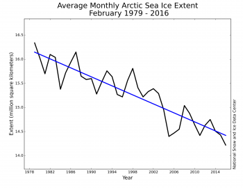
This is a comparison of the Feb ice extents during the era of satellite measurements.

http://nsidc.org/arcticseaicenews/files/2016/03/Figure3_0301-350×270.png

.

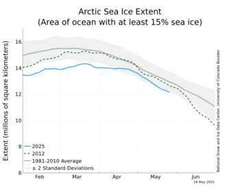
In the graphic below
The blue line is what the ice has been doing for the last 4 months. The dashed line is the record low ice year of 2012. The black line is the mean over the time satellite measurements have been made (since 1979). The gray band is +/- two standard deviations.

.

http://nsidc.org/data/seaice_index/images/daily_images/N_stddev_timeseries_thumb.png

February 2016 sea ice extent was the lowest in the satellite record at 14.22 million square kilometers (5.48 million square miles). The linear rate of decline for February is now 3.0 percent per decade.

The linear rate of summer decline (September) is over 13% per decade.

    Search

    The Control Panel

    • Log in
    • Register