A comparison of April Sea Ice Extent with previous Aprils of the Satellite era
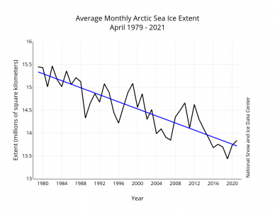
Through 2021, the linear rate of decline for April sea ice extent, relative to the 1981 to 2010 average extent, is 2.6 percent per decade (Figure 3). This corresponds to 38,600 square kilometers (14,900 square miles) per year, about the size of the US states of New Hampshire and Connecticut combined. The cumulative April ice loss over the 43-year satellite record is 1.62 million square kilometers (625,000 square miles), based on the difference in linear trend values in 2021 and 1979, which is equivalent in size to 2.3 times the size of the state of Texas.
“Same as it ever was, same as it ever was…”